Great Beaches and Dramatic Coastlines
Discover The Diversity of The Atlantic Coast
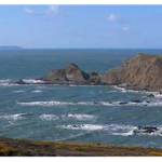
All around Bideford you will find a wide range of coastal landscapes – from the family friendly sandy beaches at Westward Ho!, Instow and Croyde Bay to the more dramatic cliffs and pebble beaches as you head toward Hartland Point.
Hartland Point is a 325 ft high rocky outcrop of land on the northwestern tip of the Devon coast in England. It is three miles north-west of the village of Hartland. The point marks the western limit (on the English side) of the Bristol Channel with the Atlantic Ocean continuing to the west. This location was known to the Romans as the “promontory of Hercules”.
If you fancy a day out in North Cornwall – Bude and the surrounding area has impressive coastal scenery. Many ships have been wrecked on the jagged reefs which fringe their base. The figure-head of one of these, the “Bencoolen” lost in 1862, is preserved in the churchyard.
There also many beautiful beaches in the Bude area, many of which offer good surfing conditions. Bude was the founder club in British Surf Life Saving. Here are a few of the beaches you could visit.
Summerleaze and Crooklets beaches are both within the town while Widemouth Bay is a few miles south of the town and offers a long, wide sandy beach. Sandymouth Beach is owned by the National Trust, and has spectacular cliffs and rock formations with shingle below the cliffs and a large expanse of sand at low tide. Northcott Mouth Beach is situated north of Bude.
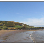
Croyde Bay
Croyde is a village on the west facing coastline of North Devon. It is rare but to some surfers the village is known as ‘The Place of Legends’ or ‘The Place of Kings’ due to the way that the village is almost perfect and so is the beach. A stream runs through the village, Croyde Stream. The rough centre of the village is at the intersection of Hobbes’ Hill, Jones’ Hill, and St. Mary’s Road, at this spot, Croyde Bridge carries the roadway over the stream.
The sandy 800m beach at Croyde stands in a sheltered bay and is the main reason that is such a popular holiday destination. The shallow slope of the beach, the mean high and low water marks are 500m apart, makes it safer for children. Down End is the headland at the south end of Croyde Bay, the larger ridge to the north is Baggy Point. A large dune system has formed past the high tide mark. Sand underlies the land surface between the beach and the centre of Croyde village, 600 m to the east. The beach forms the middle section of a trio of sandy beaches north of the Taw estuary. 6 km long Saunton Sands is 1 km to the south, 3km long Woolacombe Sands, divided into Putsborough and Woolacombe beaches, 1.5 km to the north.
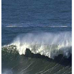
Surfing Around Croyde Bay
Croyde is a popular surfing beach, the rides are generally pretty short on the beach though, the waves tend to pitch up and break fast making it attractive to shortboarders. There is a point break off Down End that has a gnarly take off, and when it works is actually pretty good. There is a reef break at the northern (Baggy Point) end of the beach that works for about 60 minutes during some high tides, just below the National Trust car park. Putsborough, Saunton or Woolacombe may give longer rides and these much larger beaches are less crowded during the summer months. Croyde is not generally ideally suited to longboards, but again a skilled rider on a big day will find much to challenge them.
